
Onslow-North River
A managed dyke realignment project in Onslow, near Truro, will restore a parcel of land beside the Salmon and North rivers to tidal wetland. This project is a collaboration between the Nova Scotia government, researchers, and industry, and has two main goals: to increase local flood resilience and to restore an important tidal wetland ecosystem.
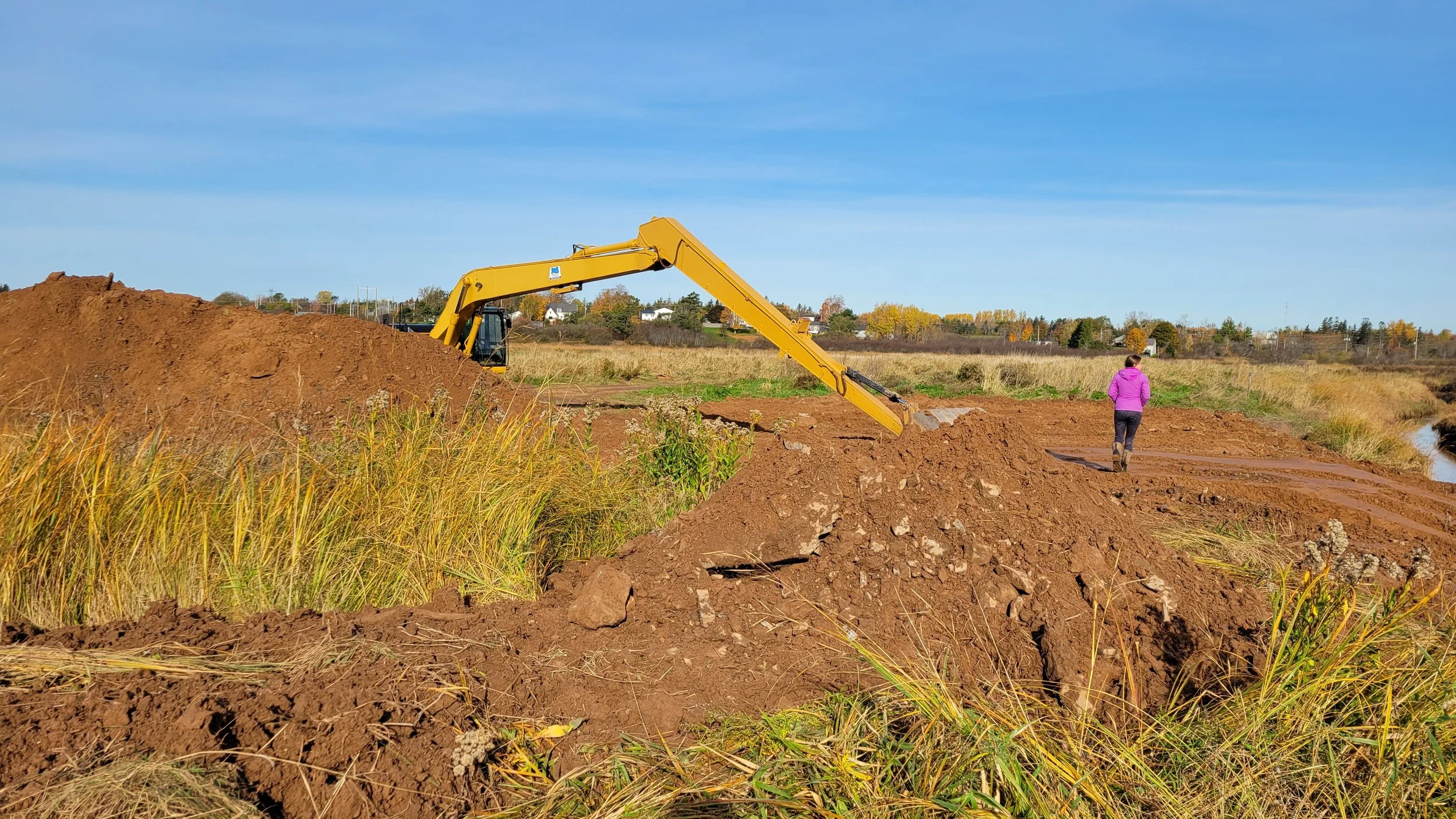
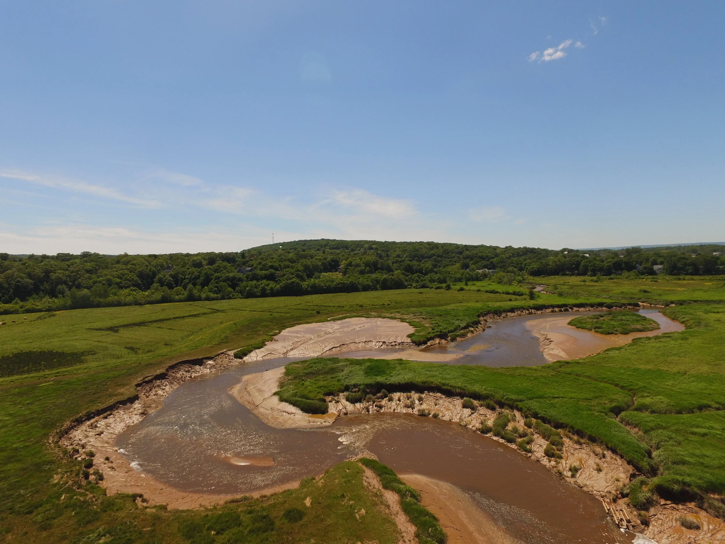
Breaching of the old dyke at Onslow-North River took place in October 2021.
In October 2021, the existing dyke along the Salmon and North rivers was breached with an excavator at several key locations, allowing tidal waters from the river to return to the floodplain (the flat land beside the river). Following the reintroduction of tidal waters, the land will gradually transition back into a tidal wetland ecosystem. The initial process of tidal wetland restoration will take approximately three years, as wetland grasses and plants begin to grow in the landscape.
This project will create fish and wildlife habitat and contribute to reducing flood risk in Truro, therefore enhancing local biodiversity and climate resilience.
Watch our video to find out more:
Managed Dyke Realignment and Tidal Wetland Restoration
What is it?

A completed managed realignment project at Belcher Street Marsh, near Kentville, N.S.
Managed dyke realignment and tidal wetland restoration is a process that involves the removal, breaching, or repositioning of existing dykes to allow for the restoration of historical and naturally occurring tidal wetlands. Managed dyke realignment increases flood resilience (reduces flood risk) in coastal communities by creating wider floodplains and foreshore marshes that absorb large amounts of water and reduce the force of waves. This means that tidal wetlands can help protect people, homes, and critical infrastructure from flooding, storm surge, and extreme weather events such as hurricanes and tropical storms.
Restoring tidal wetlands through managed dyke realignment is a nature-based climate adaptation strategy: using natural ecosystems and processes to help communities become more resilient to the impacts of climate change. In some cases, restoring tidal wetlands is a more cost-effective long-term solution than traditional approaches such as increasing the height of dykes or rebuilding aboiteaux, as well as being more adaptable for long-term resilience to a changing climate.
Because of its benefits, managed dyke realignment is an increasingly popular strategy in northern Europe and Atlantic Canada as sea levels rise and storm events increase in frequency and intensity. Nature-based solutions, including managed dyke realignment, have been recognized as a key approach to climate change adaptation by organizations such as the Insurance Bureau of Canada and the US Army Corps of Engineers, as well as by several government entities, including the European Commission and the Government of Canada.
Why is this important for Truro?

Flood risk reduction is important for coastal communities like Truro, which is particularly vulnerable to climate change impacts such as sea level rise, erosion, and storm surge. Truro also experiences flooding from rainfall during extreme weather events. Flooding was an issue at Onslow-North River when freshwater would become trapped behind the dyke, due to high water levels in the river or ice jams preventing the aboiteaux in the dyke from opening. The dyke at Onslow-North River was additionally prone to overtopping (water rising over it) and damage due to its location near the confluence of the Salmon and North rivers, where complex water patterns create increased sediment, water, and ice movement. This site is therefore ideal for managed dyke realignment, because it will reduce flood risks and decrease long-term dyke maintenance costs.
In 2014, the engineering firm CBCL Limited conducted a flood risk vulnerability study of Truro (published 2017). Using advanced mapping and flood simulation technology, they evaluated many strategies to minimize flooding and flood damage, including raising the height of existing dykes. They found that the most cost-effective solution was managed dyke realignment and tidal wetland restoration: a key recommendation of the study was to widen and restore natural floodplains to create more room for water.
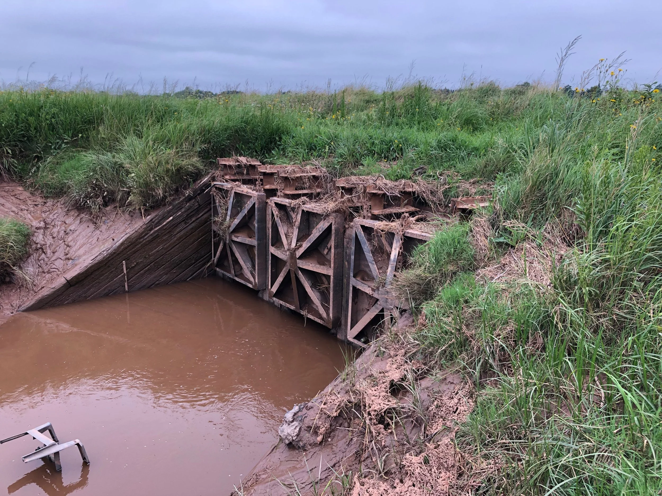
Old aboiteau at Onslow-North River (2021).
At Onslow-North River, managed dyke realignment will help reduce flooding by widening the floodplain so that it can accommodate more water during high river discharge events. During storms, excess water will be absorbed and slowly drained through tidal creek networks to the main rivers as the tide falls. The removal of the aboiteaux and the old dyke will allow for this drainage, preventing water from backing up and decreasing flooding on the nearby road, rail line, and houses. The widened floodplain will also help alleviate ice jams, further decreasing flood risks. The wetland plants at the site will additionally reduce wave energy from the river during storms. The restored tidal wetland will therefore increase Truro’s resilience to flooding and storm surge, helping to protect people, homes, and infrastructure.
In addition to flood resilience, the community will also receive valuable ecosystem benefits from the tidal wetland:

Tidal wetlands are vital habitat for fish, and offer refuge from predators.
Water filtration and increased water quality
Carbon sequestration (capture and long-term storage of atmospheric carbon dioxide)
Biodiversity and pollination services
Wildlife viewing opportunities
Restored fish access to McCurdy Brook as well as to the restored marsh
What will the process of wetland restoration look like?
After the breaching of the existing dyke alongside the Salmon River, tidal wetland restoration will occur in several stages. In the initial habitat recovery period, the area will look like a mudflat as sediment is deposited from the Bay of Fundy tides and existing plants die off. Over several years, as wetland grasses and plants begin to grow and wildlife return to the area, the land will become a vibrant and productive tidal wetland.

Belcher Street Marsh transitioning from mudflat to wetland following managed dyke realignment in 2018.
Partners and Stakeholders
Who is involved?
This project was initiated by the Nova Scotia Department of Transportation and Infrastructure Renewal, now known as the Nova Scotia Department of Public Works (NSPW), in close collaboration with the Nova Scotia Department of Agriculture (NSDA) and the Nova Scotia Department of Environment and Climate Change (ECC).
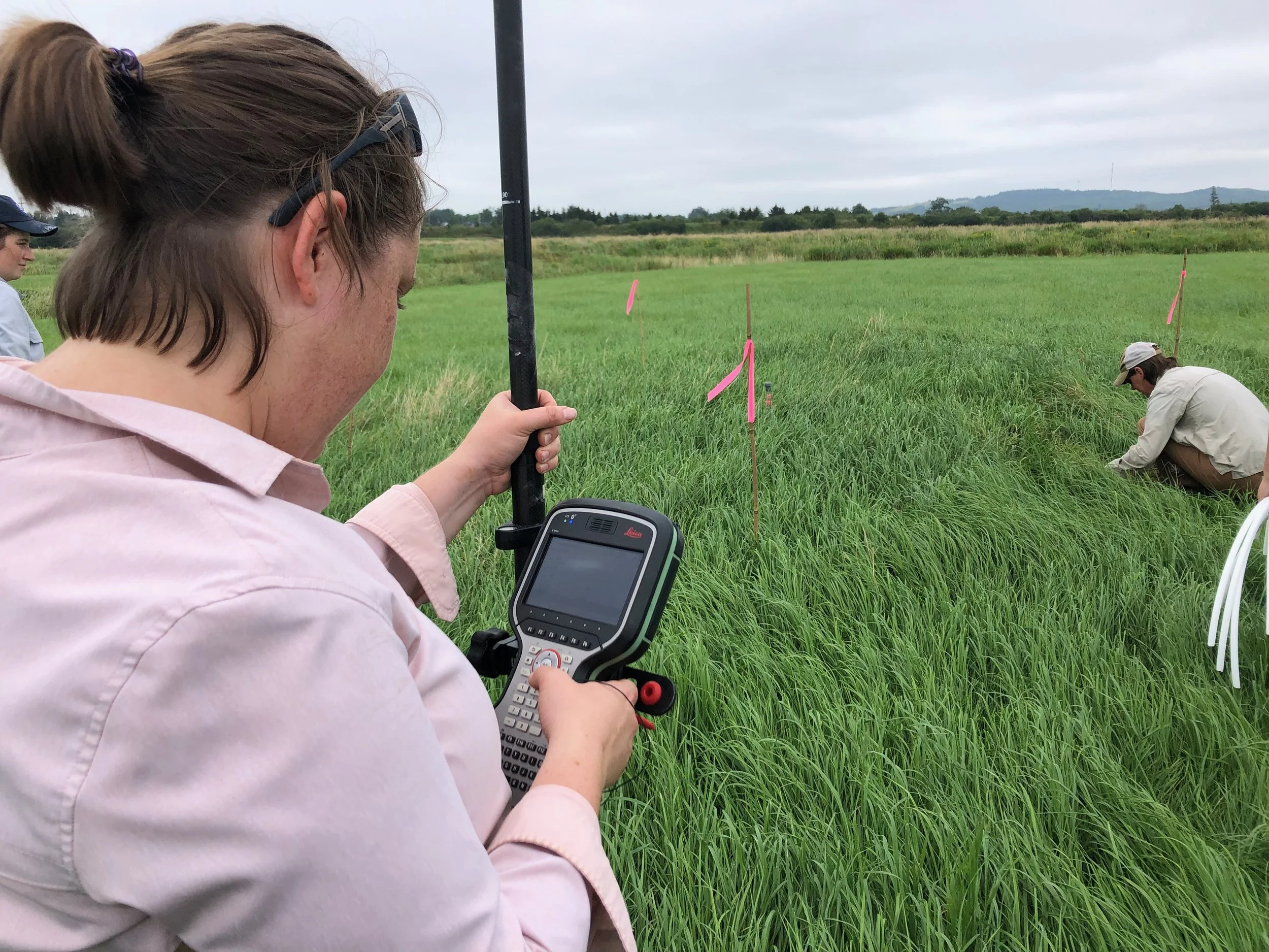
CBWES and SMU researchers at Onslow-North River (2021).
Project partners include CB Wetlands & Environmental Specialists (CBWES), Saint Mary’s University (SMU), and Queens University, who were hired to design the dyke realignment and restoration process. CBWES and SMU are additionally responsible for conducting pre- and post-monitoring to track changes at the project site over time. TransCoastal Adaptations: Centre for Nature-Based Solutions at SMU facilitates and provides support for research activities, as well as leading communications and engagement for this project.
The local Marsh Body (NS 067), a collective of local marshland owners and nearby landowners, was consulted extensively and their approval was required for all proposed changes to the site. CN Rail and Nova Scotia Power were also consulted in the design process due to a nearby rail line and power lines installed at the site.
Why was the project initiated by NSPW, ECC, and NSDA?

Tidal wetlands are important ecosystems and home to various species, including the Great Blue Heron.
A key recommendation of the 2017 Truro flood risk study publication was to widen and restore natural floodplains. This managed dyke realignment project gained support because of its clear community benefits and its importance to several key stakeholders. NSPW, ECC, and NSDA initiated the project because of its specific relevance to their operations and mandates.
NSPW originally purchased the land in Onslow to generate wetland and fish habitat compensation credits for future development projects. Environmental regulation in Nova Scotia stipulates that any alteration to wetlands due to development or the construction of new highways, roads, or causeways must be compensated with the enhancement, restoration, or creation of other wetland areas. By restoring the wetland beside the Salmon and North rivers, NSPW is able to generate wetland habitat credits for pending and future transportation projects, as well as other provincial government projects.
ECC supports this project because of its mandate to conserve and restore wetlands. In the Bay of Fundy, 80% of historic tidal wetlands have been lost due to development and dyke construction. Restoring tidal wetlands creates vital habitat for wildlife and sequesters carbon. ECC also supports the site’s potential to showcase nature-based solutions and climate change adaptation in coastal areas.
The NSDA is responsible for maintaining and repairing dykes and aboiteaux in Nova Scotia. Some dykes, such as the old dyke at Onslow-North River, require frequent and costly maintenance due to their locations. NSDA and other departments seek to strategically decommission dykes in areas where nature-based solutions provide the best option for climate change adaptation. Breaching this dyke was therefore an opportunity to reduce long-term costs for the provincial government while reducing flood risks with a climate-adaptive solution.
How do we know Managed Dyke Realignment will work at Onslow-North River?
Previous managed dyke realignment projects, including at the site above, Belcher Street Marsh, have proven successful.
This project will be Nova Scotia’s third managed dyke realignment project. Previously, managed realignment has occurred at Belcher Street Marsh along the Cornwallis River near Kentville and at Converse Marsh in Fort Lawrence near Amherst: both sites now have plant growth and are continuing to recover. Other types of tidal wetland restoration, including dyke breaches, have been implemented successfully in Nova Scotia for over 15 years, starting with those at Cheverie Creek and Walton River in Hants County in 2005. NSPW, NSDA, CBWES, and SMU have collaborated on the majority of these projects.
This project at Onslow-North River was designed following CBCL Limited’s 2014 flood risk vulnerability study (published 2017), which modelled that managed dyke realignment and tidal wetland restoration was the most cost-effective flood risk solution for the area. The managed realignment design for Onslow-North River, including the construction of new dykes and the breach plan for the old dyke, was created by CBWES and researchers at SMU and Queens University after a thorough assessment of baseline conditions and hydrodynamic modelling of water levels and velocities within and outside the restoration site. These designs were assessed for their ability to ensure habitat restoration and protect nearby infrastructure. Site-specific hydrology modeling from CBCL also helped inform additional drainage and ditching.
Researchers at CBWES and SMU will be conducting post-restoration monitoring at Onslow-North River over a five-year period to ensure proper habitat recovery. This comprehensive monitoring program will measure a range of biophysical variables, including sediment accretion, carbon sequestration potential, and changes in vegetation, fish and other fauna, elevation, hydrology, water quality, and soil quality. In addition, this site will serve as a “living laboratory” for ongoing research.
Project Design
The managed dyke realignment project includes breaching the old dyke at several locations, excavating channels, and building two new dykes where necessary. Archaeological investigations were carried out in 2016–2018 to clear the area for the dyke work and tidal flooding.

Map of Onslow-North River project site; design map by CBWES with interpretive captions by TCA.
Frequently Asked Questions
HOW WAS THIS LAND ACQUIRED?
The Nova Scotia provincial government purchased the land at Onslow-North River in 2016 after it was put up for sale by the previous owner and no farmers indicated interest in purchasing the land.
WHO IS FUNDING THIS PROJECT?
This project is paid for by the provincial government (NSPW and NSDA) through its annual operation budgets. This two-year construction project is also funded 50 percent by Public Safety Canada’s National Disaster Mitigation Program.
WHY SHOULD WE WORRY ABOUT CLIMATE CHANGE IN TRURO?
Researchers predict that by the year 2100, sea levels in the upper Bay of Fundy will rise by up to 1.20 metres (OECD Report, Responding to Rising Seas, 2019). Truro is particularly vulnerable to sea level rise, erosion, and storm surge resulting from extreme weather events, which are increasing in frequency and intensity due to climate change. Truro also experiences annual flooding from rainfall during extreme weather events. Climate change is happening now, and its effects will grow over time. The best way to protect people and communities from the impacts of climate change is to take proactive climate adaptation measures.
WILL THIS PROJECT STOP TRURO FROM EVER FLOODING AGAIN?
The causes and history of flooding in Truro and the surrounding region are complex. This project is one part of a longer term-strategy to decrease flood risk to Truro as indicated in the CBCL 2017 report. The pre- and post-breach monitoring and research activities will provide real-world data to quantify benefits such as flood mitigation, carbon storage, and habitat creation, as well as to identify potential applications in the future.
WON’T ALLOWING TIDAL WATERS INTO THE AREA INCREASE FLOOD LEVELS IN TRURO?
No. Hydrodynamic modelling of the site shows that there will be reduced water levels outside of the boundaries of the restored wetland since the site is located close to the upper limit of the tides.
WHAT WILL THE IMPACT BE ON ICE JAMMING?
The restored tidal wetland and the widened floodplain will create a “parking lot” for ice, helping to alleviate ice jams. This will also help to minimize flood risks to the area.
WILL THERE BE INCREASED EROSION AS MORE WATER MOVES THROUGH THE SITE?
Small, localized erosion may occur at the inlet and opposite bank.
WILL A TIDAL WETLAND LEAD TO MORE MOSQUITOES IN THE AREA?
Concerns were raised during the planning process that the restored tidal wetland could create breeding grounds for mosquitoes, potentially disturbing nearby residents and tourists. These concerns were addressed during consultations with the Marsh Body, and mosquito experts were brought in to discuss strategies for mitigating mosquito populations. Mosquitoes typically breed in standing water, or areas where water will pool. The design for this project therefore minimizes standing water with effective drainage via the breached dykes and channels, ensuring that mosquito breeding areas are greatly reduced.